Naknek River
Appearance
| Naknek River | |
|---|---|
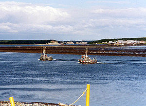
 Salmon boats on the Naknek River | |
| Location | |
| Country | United States |
| State | Alaska |
| Borough | Bristol Bay |
| Physical characteristics | |
| Source | Naknek Lake |
| • location | Katmai National Park and Preserve |
| • coordinates | 58°41′04″N 156°25′25″W / 58.68444°N 156.42361°W[1] |
| • elevation | 33 ft (10 m)[2] |
| Mouth | Kvichak Bay |
• location | 2 miles (3 km) west of Naknek, Alaska Peninsula |
• coordinates | 58°43′07″N 157°03′56″W / 58.71861°N 157.06556°W[1] |
• elevation | 0 ft (0 m)[1] |
| Length | 35 mi (56 km)[3] |
Naknek River is a stream, 35 miles (56 km) long, in the Bristol Bay Borough of the U.S. state of Alaska.[3] It flows west from Naknek Lake to empty into Kvichak Bay, an arm of Bristol Bay.[1] The river and lake are both known for their sockeye and other salmon.[4]
The village of King Salmon is near the head of the river; Naknek and South Naknek lie at its mouth, on the north and south banks respectively.[5] The head lies within Katmai National Park and Preserve.[5]
See also
[edit]References
[edit]- ^ a b c d "Naknek River". Geographic Names Information System. United States Geological Survey. January 1, 2000. Retrieved November 29, 2013.
- ^ Derived by entering source coordinates in Google Earth.
- ^ a b Orth, Donald J.; United States Geological Survey (1971) [1967]. Dictionary of Alaska Place Names: Geological Survey Professional Paper 567 (PDF). University of Alaska Fairbanks. p. 671. Archived from the original (PDF) on October 17, 2013. Retrieved November 29, 2013.
- ^ Limeres, Rene; Pedersen, Gunnar; et al. (2005). Alaska Fishing: The Ultimate Angler's Guide (3rd ed.). Roseville, California: Publishers Design Group. pp. 232–33. ISBN 1-929170-11-4.
- ^ a b Alaska Atlas & Gazetteer (7th ed.). Yarmouth, Maine: DeLorme. 2010. pp. 49–50. ISBN 978-0-89933-289-5.

